Just got off watch. Sailing nicely downwind on just the Code 0 in 15+ knots wind with a following short period swell. Renee made a nice spaghetti dinner. There's nobody out here but us and the occasional big ship in the far distance. The stars are amazing and the moon should rise soon. It's warm; Renee is still wearing shorts with a light fleece shirt.
We've logged 55 nm; 180 left to go.
Time to grab a little sleep before my 00:00 to 03:00 watch, which always comes too quickly after I've fallen asleep.
Tuesday, December 8, 2015
Sailing to Mazatlan 1
We're on our way to Mazatlan. We left La Paz at 10:00 am after an expensive night's stay in Marina Costa Baja. We had heard it was a less expensive marina, but that's for month long stays, not overnight, which I figured out after we had checked in and done all the paperwork. Oh well. We had a nice dinner of a small roasted skipjack tuna that Renee caught on the way from Ensenada Grande.
The morning's sail north through the Bahia de La Paz was a nice close reach in 10-15 knots with little swell. Then we turned east to go through the Canal de San Lorenzo and the wind was on the nose at 20 knots with very steep chop which we powered through under motor. When we turned southeast to pass through Canal Cerralvo, the wind died and the chop subsided but about every 10th wave is big enough to roll the boat, slam the boom from side to side, just to be annoying.
We're making slow progress at under 4 knots, but we're determined to sail as much of this passage as reasonably possible. At this rate, it will take us almost three days to reach Mazatlan, but that ETA will hopefully improve with periods of increased wind.
So, I made a really big mistake. I forgot to replenish the beer supply before we left La Paz! OMG! I have only three beers for the whole trip! I don't know if I'll make it.
Hmmmm...I have barley, yeast and sugar. Maybe I can make a boat brew?

Monday, December 7, 2015
Ending Leg 3, Beginning Leg 4
To recap:
Leg 1 was sailing down the California coast from San Francisco to San Diego.
Leg 2 was the Baja Ha-Ha, from San Diego to Cabo San Lucas.
Today, we officially ended Leg 3, sailing the Sea of Cortez.
Tomorrow, we officially start Leg 4, the Pacific Coast of Mexico.
We set sail from La Paz tomorrow morning (with full fuel tanks) for Mazatlan (no bar to cross) with a good weather forecast. It will be a two-day passage, downwind, thank goodness.
Here are some pictures from the past several days:
 |
| The mission at San Ignacio |
 |
| The town square in the oasis town of San Ignacio |
 |
| Rocks and turquoise water at Ensenada Grande...never get tired of them |
 |
| The beach and trailhead at the end of Ensenada Grande |
 |
| The rugged east coast of Isla Partida, looking north |
 |
| The rugged east coast of Isla Partida, looking south. |
Sunday, December 6, 2015
Ensenada Grande
Well, I can't say how our crossing of the Sea of Cortez would have turned out. The crossing itself probably would have been fine, but if the wind on the other side was like it was here, I doubt we would have been able to get across the bar into Altata. It was probably overly conservative to have changed course, but we're glad we did as we have been enjoying Ensenada Grande. We also realized that our next ports of call, Mazatlan and Puerto Vallarta, are urban areas with all the "amenities". We really like the natural beauty and relative solitude of Baja and the Sea of Cortez and are glad we didn't cut our time here any shorter.
E. Grande is a larger anchorage with three lobes. We're in the longest and deepest lobe, tucked in near the shallow water at its end. The wind has been howling (again!) and the boat swinging on its anchor, which compromises our satellite reception. The few boats that were anchored here last night have left and we have the place to ourselves. So, near total isolation.
We took a hike up an arroyo to top of the east side of the island. This time we had bug repellent but, it figures, there were no bugs at all! It was a relatively easy hike up to the top where we had a picnic lunch on the edge of a cliff looking over a rugged coastline and whitecapped sea. The snorkeling around here is good, too, although the wind has stirred things up a bit and decreased visibility since yesterday.
Tomorrow (Monday) we head for La Paz to fuel up and then Tuesday we'll head across to Mazatlan in what looks to be good sailing weather.
Friday, December 4, 2015
Change In Plans...Again
Well, we started out across the Sea of Cortez, but there is no wind and none is expected until well after midnight. Normally we would motor until we had enough wind to sail. However, our fuel tanks are only about 3/8 full. That's plenty to get us to Altaca, but if we can't get across the bar, which is a real possibility, we have to continue another 120+ miles to Mazatlan in what looks to be highly variable winds. I'm not comfortable with burning through a good portion of our fuel tonight and then being short if we can't get into Altaca to fill up. So we're heading back to La Paz to fuel up and then will leave from there direct to Mazatlan on the next good weather window. On the way we'll stop and explore a couple of the bays we passed by on Isla Espiritu Santo as we were running away from Hurricane Sandra.
It's nice not being on a tight schedule and being able to "go with the flow". Maybe I'm a bit chicken-hearted, but Renee and I came to the same decision after quite some consideration. Bottom line, we wouldn't have left for an almost 300 mile passage with less tanks less than half full. So we're not.
It's nice not being on a tight schedule and being able to "go with the flow". Maybe I'm a bit chicken-hearted, but Renee and I came to the same decision after quite some consideration. Bottom line, we wouldn't have left for an almost 300 mile passage with less tanks less than half full. So we're not.
Sailing Across the Sea of Cortez, Ordeals and Adventures
We're leaving tonight to sail across the Sea of Cortez from the Baja peninsula to the mainland of Mexico. We're starting off from an anchorage and heading for a port that are both different from what we originally planned.
We returned to Puerto Escondido Wednesday night from our road trip to Santa Rosalia and San Ignacio. I wrote a bit previously about the mining town of Santa Rosalia. Our side trip to San Ignacio, 40 miles further north and inland was a spur of the moment idea. It was worth the time and effort as it is a very small, very pretty little town in the middle of an oasis with a large fresh water lake. The 18th century mission is simple but elegant and very well preserved, with a miniature desert botanical garden in its courtyard.
We spent yesterday morning returning the rental car, buying tortillas, postcards and stamps and having coffee (me) and doing laundry (Renee...thank you). We left the harbor around noon headed towards Agua Verde, an anchorage that we had wanted to visit on the way north but bypassed due to weather. It was a nice leisurely downwind sail in light winds, which we enjoyed a little longer than we should have as the sun fell below the hills before we reached the anchorage. We turned on the motors to get anchored before dark but were thwarted by a small dorado that decided to take Renee's hook trolling behind us. We were happy for the fresh fish, but by the time we made it into the small anchorage it was dark and filled with other boats. We probably could have anchored there if we could have assessed conditions in daylight, but it was impossible to do so in the dark. That was a bummer, because we didn't have a Plan B on the shelf, ready to go.
We motored slowly out of the anchorage through bouncy swells as I looked at the charts and tried to figure out our options. The most obvious option was to head to the next anchorage south and I started plotting a course to get us there. I entered GPS waypoints to get us through a pass between a point of land and an offshore reef. Then I entered GPS waypoints to get us around another reef and into the anchorage. Then I thought, "Not bloody likely." (Actually, I thought in American English, but I like the sound of the British expression better.) No way was I going to navigate Intermezzo around reefs and "rocks awash" in darkness with only GPS coordinates.
I could think of only three other alternatives. We could head back to Puerto Escondio and start over tomorrow. That would be safe but would mean motoring upwind through steep chop for several hours. We could head offshore and heave-to (park the boat under sail) for the night. Renee didn't like that option, bobbing around, feeling seasick and going nowhere. Or we could start sailing across the Sea to the mainland a day earlier than planned. I didn't like that because neither the boat nor we were properly prepared for an overnight offshore crossing. However, as a sailor, I like having sea room and I would rather be out in the middle of the sea with very little to crash into than close to shore with lots of hard stuff all around.
I was reluctantly moving in the direction of sailing across the Sea to Topolabampo, slowly motoring offshore, shaping a course, estimating arrival time and identifying the minimum we needed to do to be properly set up. I really, really didn't like the idea of doing this and was more than a bit worried. Okay, I'll admit it, I was just crossing into being scared. I looked at the chartplotter again, to make sure there wasn't a fatal flaw in my plotted route and noticed the purple line that indicates Intermezzo's track, the path she's previously sailed along.
Ahah! Another alternative! We could follow the track line back to the Los Gatos anchorage. We had "bread crumbs" that would lead us back in the dark to the exact spot where we had safely anchored on Thanksgiving and it would only take us a couple of hours to get there. What a relief. I altered course accordingly in much better spirits.
Along the way, another boat, Indigo, contacted us on the VHF to chat. We told them our story and they offered to lead us into the anchorage they knew very well and were heading to for the night. We were grateful for the offer and another option to consider. As we approached Los Gatos, we told Indigo we were going to nose in and see if there was room and, lo and behold, a boat anchored in Los Gatos overheard our conversation. They told us it was only them and one other boat and that they would turn on extra lights to help us orient ourselves. We ended up anchoring with no difficulty within about 50 feet of where we were on Thanksgiving. It was a rolly night in northeast swell, but we were safe and could spend the next day getting properly ready for our crossing.
Finding ourselves about 20 miles further south than planned and looking at the weather forecasts, we've decided to sail across to the port of Altata, which is between Topolabampo to the north and Mazatlan to the south. It sounds like an interesting place, with a new marina, traditional sailing shrimp boats and "famous" for its seafood restaurants on its malacon. The only tricky part is getting into the port, which requires crossing a shallow bar with breakers each side and constantly shifting shoals. If you know the South Shore of Long Island, it looks like Moriches Inlet. Purportedly, we can call the marina on the VHF and they will send out a panga to guide us through this treacherous passage. If that doesn't work, this time we do have a Plan B on the shelf, ready to go. We'll just continue sailing south to Mazatlan.
We're leaving Los Gatos at sunset tonight and we should arrive at the inlet to Altata early Sunday morning. Making the entrance into Altata seems like a pain in the neck, but there is a saying of which I am fond: "The difference between an ordeal and an adventure is attitude."
Tuesday, December 1, 2015
Massive Photo Upload
We're on a mini road trip to Santa Rosalia, having rented a car and left Intermezzo by herself anchored in Puerto Escondido. It was a nice 120 mile drive through desert scenery, stopping in the town of Mulege for lunch. Mulege wasn't that interesting. Santa Rosalia is.
Santa Rosalia's heyday was when it was a French mining town in the late 19th, early 20th century. The old mining and smelting infrastructure is still around, rusting and decaying. There is still an active mining going on here and the mining town character has been preserved. The town is rough around the edges, but seems like an thriving community; we passed by a cultural center where people were taking music lessons, a community gym with volleyball being played and the little stores around town are all stocked up and decorated for the Christmas season.
We're staying in the Frances Hotel, an historic place that purportedly was the dormitory for the girls who worked in the brothel during, back in the day. It's a comfortable old place and will be the first time we've slept on land since leaving Petaluma.
I'm taking advantage of a decent broadband connection here in our hotel in Santa Rosalia to upload a ton of photos taken over the past couple of weeks.
Here they are. Enjoy!
Isla Espiritu Santo
 |
| The varied and striking geology of the island is apparent from a distance |
 |
| Motoring due to light winds gave us the opportunity to take a detour through some small islands of the coast of the main island. |
 |
| More island geology. "Grand Canyon By the Sea" |
 |
| The island is indented with many coves, most with a beach and some greenery at their innermost portion. |
Caleta Partida
 |
| A chartplotter view of Caleta Partida as we entered, showing several of the many other anchorages indenting the coasts of I. Espiritu Santo and I. Partida. |
 |
| A stunning sunset welcomed us to Caleta Partida on our first evening |
 |
| We took the dinghy to the cove next door to find the trail up to the top of the ridge, the rim of the crater of a long extinct volcano. |
 |
| Renee getting ready for the hike, before the mosquitos started biting. We didn't stand still long after that. |
 |
| The trail head at the mouth of an arroyo. |
 |
| Flowers decorating a cactus. |
 |
| One of several good-sized lizards we saw on the trail. This one is about a foot long. |
 |
| Renee looking at something and a tree bending over to examine Renee more closely. |
 |
| A panorama of Caleta Partida from the ridge of Isla Espiritu Santo. To the north is Isla Partida; the gap between the two islands is to the right. If you look closely, you can see Intermezzo and the half dozen boats with whom we shared the anchorage. |
 |
| Intermezzo looking very tiny anchored in Caleta Partida. |
 |
| Hiking at the top of the ridge. Hard to believe it, but there were more hungry mosquitos up here than in the arroyo below. |
Ensenada Embudo
 |
| This is the tiny cove at the north end of Isla Partida where we anchored Intermezzo to swim with sea lions at two tiny outlying islands. Only room for one boat and a private beach for a picnic and expand the extent of tanned skin. |
Bahia Los Gatos
We took dozens of pictures of the rock formations at Bahia Los Gatos because we found them so beautiful and interesting. It was hard to select the ones to post, so I uploaded a bunch.
 |
| The Baja coast on the way to Bahia Los Gatos. |
 |
| Intermezzo anchored in Bahia Los Gatos. |
 |
| One of the many pictures of the rock formations at each end of the bay. We hiked up to the top of this one. |
 |
| Another of many rock formation pictures; I won't caption them all. |


 |
| Bahia Los Gatos from the crest of the rocks we hiked up. |
 |
| A panorama that provides a perspective of the landscape beyond the bay. |
 |
| Hiking the narrow crest of the rocks. |
 |
| Dr. Livingston, I presume? |
 |
| Renee and the turtle shell I found on the beach. |
 |
| Our modest Thanksgiving dinner anchored by ourselves at Bahia Los Gatos. "Pollo de Celebrar", garlic roast potatoes, mushrooms in escabeche, mixed vegetables and (vintage) cranberry sauce, all washed down with a delicious 2008 Rafanelli zin. |
Santa Rosalia
 |
| Santa Rosalia was and still is a mining town. |
 |
| Ruins of the smelter on the waterfront. |
 |
| Hotel Frances, where we slept on land for the first time since leaving Petaluma on October 5. |
 |
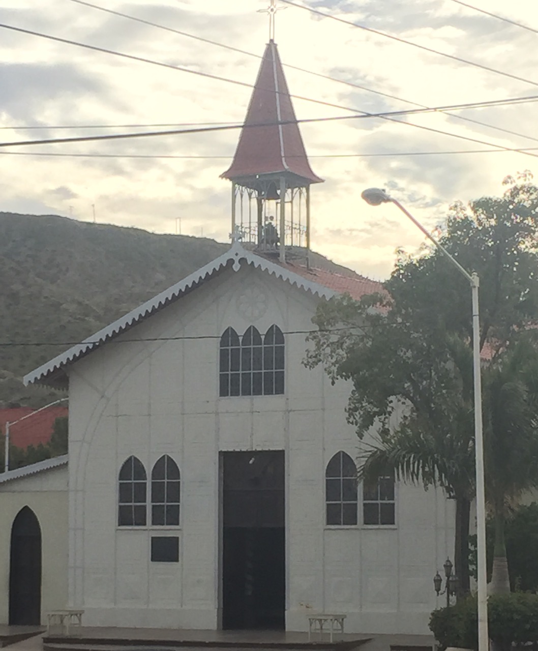
| This church was designed by Gustav Eiffel. It is a prefabricated structure, once exhibited at the Chicago Worlds Fair and shipped to Santa Rosalia from Belgium. |
 |
| A typical street in the Santa Rosalia town center. |
Subscribe to:
Posts (Atom)