Sunday, May 14, 2023

Bahía Willard, Overnight Passage, Next to Last Stop

San Felipe, Baja California

Intermezzo anchored in San Felipe harbor

We departed beautiful Puerto Refugio Friday morning (May 12th) and had a pleasant but uneventful 9-hour trip to Bahía Willard. Bahía Willard is a nicely protected anchorage, but I was not impressed upon arrival. The landscape looked arid and bland, the little settlements on the north and south shores looked scrappy. It was quite the letdown.

On Saturday I ventured in the dinghy to the settlement of Papa Fernandez to see if I could get some lunch. The settlement has a restaurant, a boat ramp, campsites and a collection of very modest vacation homes built on rented lots. It also has an interesting history, the following copied from the website http://www.papafernandez.com:

The tiny settlement know as Papa Fernández takes its name from its centenarian founder Gorgonio (Papa) Fernández who first established a fish camp there in the 1950's. Later he moved there with his family (from Loreto in a rowboat), and has provided a welcome stop-over for Baja adventurers traveling the rugged dirt track which leads south along the Sea of Cortez from San Felipe to Calamajue Canyon and beyond. Papa passed away on February 20, 2001 at the age of 104 years. 

Early Spanish explorers recognized that the well-protected bay formed by Isla San Luis Gonzaga and the Punta Willard peninsula was a unique natural resource. The bay was first noted in written history in a report to the King of Spain by Fernando P. Consag, a Jesuit Missionary from Mission San Igancio who, with 6 soldiers and a few Indians in 1746, explored the Baja peninsula coast from the south up to the Colorado River Delta. As large ships were very scarce, this was done with four sail canoes.

The original Spanish-dug well still supplies water to the Papa Fernández settlement. Remains of the Jesuit storehouse that was used by Spanish ships to supply Mission Santa Maria near Cataviña can be found nearby.

I dragged the dinghy up onto a rocky beach and walked a few hundred yards to the Papa Fernandez restaurant. When I got there, it was closed and deserted. I sat down on a picnic bench, hungry and a bit disappointed. One of the boat ramp men asked me if I wanted anything. I replied that I would like to have lunch. He told me to wait a moment and walked to a nearby house. A friendly woman emerged from the house, opened the restaurant and cooked me a very nice meal of an enchilada, a chile relleno and a taco, plus a side of papas fritas. I washed it all down with a cold bottle of water (there was no beer). My impression of the place went up a bit. Would have been more if they had beer.

The tidal ranges in the northern Sea of Cortez are large. The difference between high and low tide in Bahía Willard on Saturday was 11 feet. I left the dinghy on the beach with the stern at the edge of the water during a falling tide. When I returned in an hour after eating lunch, the stern was 10 feet from the water's edge.

The stony beach at the Papa Fernandez settlement

The sail from Bahía Willard to San Felipe is just under 80nm, a 15-hour trip, so I decided I would depart the in the evening and sail through the night so that I would arrive in San Felipe in daylight. I spent the rest of Saturday repairing a big ding in the corner of port swim step.  It was tricky to replicate the original gelcoat profile. I slathered the gelcoat on thick and then spent a considerable time sanding it to conform to contours of the adjacent surfaces. I still need to put a final coat on, but it looks much better than I expected. When I'm finished, you won't notice the repair unless you look for it.

Sunset at the start of the overnight trip to San Felipe

We weighed anchor at 5:30pm and sailed into the sunset. There was no moon, but with no light pollution, the stars dimly lit the coast and sea and Mars shown brightly to the west, reflecting as a beam of light on the surface of the water. Later, I said hello to a crescent moon as it rose in the southeast.

We sailed in light-to-moderate winds most of the way to San Felipe. The sea was deserted except for one fishing boat that passed us several miles away going south. No chatter on the radio. No vessels showing up on the AIS. Nothing on the radar.

There were lots of birds, though. Gulls, pelicans and boobies either sitting in the water or flying low in the darkness. Some would circle around the boat, looking curious. One booby flew alongside me for a couple of minutes, only a few feet away, looking at me, right at eye level. S/he looked friendly and I appreciated the company.

We entered the breakwater-protected harbor of San Felipe at 10am while the wind was howling at 22 knots. I was concerned about finding the right place to anchor to accommodate the 15-foot tidal range and had to move skillfully and quickly to set the anchor where I wanted it in such conditions. We anchored at roughly high tide and I've watched the water recede, exposing sand bars and sunken boats, the rock breakwaters and pilings seeming to grow in height through the day.

I walked over the Port Captain's office, assuming it would be closed on Sunday. When I got there, there were two men working on a car. I asked them if I needed to officially check in and they didn't seem to know. They called the Port Captain who walked over from his house next door and, with quite a bit of fumbling around, instructed one of the guys on the check-in procedure. I don't think boats check in here very often. I'm one of only a few foreign vessels in the harbor and the only boat anchored out.

This is the next to last stop on my trip to Puerto Peñasco. Tomorrow I'll try to work out the logistics to prepare for hauling out. I originally intended to head to Puerto Peñasco on Tuesday and spend a week or so getting the boat ready,  but there seems to be very little dock space there. If I can't find a suitable berth, I'll have to stay here to do the prep work and then sail to Puerto Peñasco the day before my scheduled haul out. Either way, I'm going to try and move the haul out date forward and expedite the whole process.



Thursday, May 11, 2023

The Northern Sea of Cortez

Puerto Refugio, Baja California

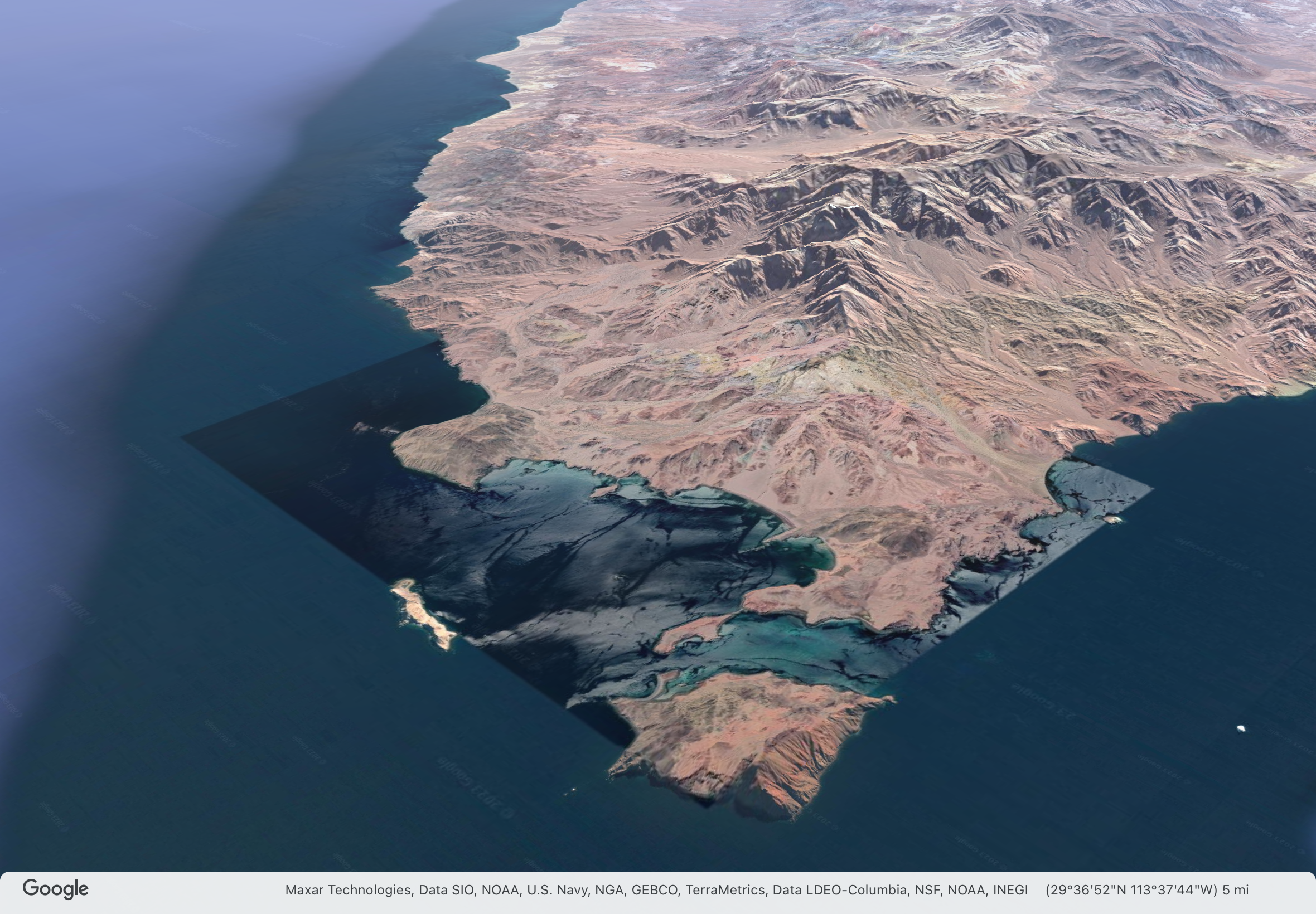
Google Earth image of Puerto Refugio and the north end of  Isla Angel de la Guarda

In yesterday's post, I forgot to mention that Port Refugio is a new place in the Sea of Cortez for me, I've never been here before and this is the furthest north I've sailed. We are now most definitely in the northern Sea of Cortez, by several measures.

There are two states on the Baja California peninsula, Baja California and Baja California Sur (South). The border between them is roughly halfway along the peninsula right along the line of latitude 28.0 degrees N. The state of Baja California runs north to the US border, Baja California Sur runs south to Los Cabos at the tip of the peninsula. We crossed state border during the passage from Santa Rosalía to Bahía San Francisquito.

The US National Weather Service divides the Sea of Cortez (Gulf of California) into three zones, northern, central, and southern. The dividing line between the central and southern zones is also at about latitude 28N on the Baja side of the sea. The weather here is more closely affected by what's happening in the Great Basin of the US than the south. The winds are stronger in the winter, though I'm not seeing a big difference between north and south this time of year.

Puerto Refugio is at latitude 29.3 degrees N, almost 80nm north of this dividing line.  It was the northern limit of John Steinbeck's voyage in 1941 on the Western Flyer which he chronicled in his book Log from the Sea of Cortez.

Voyage of the Western Flyer from Steinbeck's Log from the Sea of Cortez

As the Western Flyer sailed north from Loreto, Steinbeck writes about the difference in the fauna of the southern and northern sea and the interesting puzzle it presented at the time to biologists:

Little fragments of seemingly unrelated information will sometimes accumulate in a process of speculation until a tenable hypothesis emerges. We had come on a riddle in our reading about the Gulf and now we were able to see this riddle in terms of the animals. There is an observable geographic differential in the fauna of the Gulf of California. The Cape San Lucas-La Paz area is strongly Panamic. Many warm-water mollusks and crustaceans are not known to occur in numbers north of La Paz, and some not even north of Cape San Lucas. But the region north of Santa Rosalia, and even of Puerto Escondido, is known to be inhabited by many colder-water animals, including Pachygrapsus crassipes, the commonest California shore crab, which ranges north as far as Oregon. These animals are apparently trapped in a blind alley with no members of their kind to the south of them.

The problem is: “How did they get there?” In 1895 Cooper advanced an explanation. He remarks, referring to the northern part of the Gulf: “It appears that the species found there are more largely of the temperate fauna, many of them being identical with those of the same latitude on the west [outer] coast of the Peninsula. This seems to indicate that the dividing ridge, now three thousand feet or more in altitude, was crossed by one or more channels within geologically recent times.”

Having reviewed the literature, we can confirm the significance of the Cedros Island complex as a present critical horizon (as Carpenter did eighty years ago) where the north and south fauna to some extent intermingle. Apparently this is the very condition that obtained at Magdalena Bay or southward when the lower Quaternary beds were being laid down. The present Magdalena Plain, extending to La Paz on the Gulf side, was at that time submerged. Then it was cold enough to permit a commingling of cold-water and warm-water species at that point. The hypothesis is tenable that when the isotherms retreated northward, the cold-water forms were no longer able to inhabit southern Lower California shores, which included the then Gulf entrance. In these increasingly warm waters they would have perished or would have been pushed northward, both along the outside coast, where they could retreat indefinitely, and into the Gulf. In the latter case the migrating waves of competing animals from the south, which were invading the Gulf and spilling upward, would have pocketed the northern species in the upper reaches, where they have remained to this day. These animals, hemmed in by tropical waters and fortunate competitors, have maintained themselves for thousands of years, though in the struggle they have been modified toward pauperization.

So, the Baja peninsula was once crossed by channels, roughly at the same latitude as the state border and this allowed the Pacific and Sea of Cortez fauna to mix. When the channels disappeared, a segregation of species occured. My own observations leave me with no doubt that the ecologies of the northern and southern Sea of Cortez are quite different. The water is colder here, there shores more rocky, the topography, above and below the water, more severe. It is less tropical here, more temperate. I'm sure a marine biologist would observe big differences in the marine life underwater.

From a human perspective, the northern sea is more remote, less people, less boats. There is less of a vacation feel to the place. All the other sailors I've spoken to (and there haven't been many) are also heading to Puerto Peñasco with purpose, to haul out for hurricane season. Apart from the occasional small recreational fishing boat from nearby Bahía Los Angeles, the only other boats have been a few small rough steel commercial fishing boats. 

From this point on, I will be traveling waters and stopping in anchorages new to me (and uncharted by the Western Flyer). Tomorrow morning, we leave for Bahía Willard.

Wednesday, May 10, 2023

A Beautiful Place


Puerto Refugio, Sea of Cortez

Middle Bight, Puerto Refugio at sunset

After spending several days anchored in the calm waters of Puerto Don Juan, we set off for Puerto Refugio yesterday morning and arrived in the afternoon.  This is one of the most beautiful places I've ever visited.

Last time we were in Puerto Don Juan in 2017, I discovered a mother lode of clams in the shallow waters off the main sandy beach. I was looking forward to another delicious clam dinner so at low tide on Sunday morning, I anchored the dinghy in the shallows, hopped out and started digging with my feet. There were even more clams this time! I had two dozen in my bucket in less than 15 minutes. With the clamming done, I took a nice long hike through the desert in beautiful cool weather. I ate the clams for dinner. Yum.

Puerto Don Juan at low tide, clam bed extraordinaire 

In my last post, I wrote about how Puerto Don Juan was teeming with sea lions feeding on sardines. Well, I guess sardine hunting must require a full or nearly-full moon because it seems most of the sea lions departed on Monday, three days after the full moon on Friday. Many of the pelicans left with them. It was like the Thanksgiving holiday had come to an end and all the visitors left with full bellies, leaving the house feeling quiet and empty.

The sail here was easy, mostly motoring in light headwinds, an hour or so of sailing on just the jib with a nice breeze. Puerto Refugio is located at the northern tip of the large, long island of Angel de la Guarda. We sailed between the island and the Baja peninsula through the Canal de Ballenas (Whale Channel) but didn't see any whales.

Angel de la Guarda is a beautiful island. The closer we drew to it, the more beautiful it became. The rugged terrain stands out in three dimensional relief, the light blue sky its backdrop, the dark blue sea like an apron,  the land striated by geology of many colors - ochre, slate grey, brown, tan,  smokey purple, burnt maroon, olive green - muted, like pastels, but majestic and captivating.  My writing does not do it justice. Photographs help, but still fall short.


Isla Angel de la Guarda

Puerto Refugio is formed by two points at the northernmost end of la Guarda, between which are three bights separated by rock reefs. The anchorages in the bights are well-protected from south, east and west winds and waves. A small island, Isla Mejia and two islets provide some shelter from northerly winds and swells. It is a jewel box of an anchorage, mountains rising steeply from the shoreline, vegetated with dark green cacti, a yellow vine-like grass, and light green desert shrubs. It is very beautiful.

We anchored in the middle bight along the north shore of la Guarda yesterday which provided great protection against the strong westerly winds that blew hard last night and early this morning. However, later the wind shifted to the north sending swell into the anchorage. The island deflected the wind so that we were sitting broadside to the swell, rolling quite a bit. So I moved the boat into the little bay between Isla Mejia and la Guarda, a very pretty spot and much more comfortable.

This afternoon I explored the bay on the paddle board. As I ventured down a little finger of the bay, the gulls on the shore started yelling at me.  Then several took to flight and started swooping down upon me in a very hostile and aggressive manner. I'm getting pretty good at not falling off the paddle board, but these gulls were getting me worried. It was then that I noticed fuzzy grey gull chicks among the gulls on the shore. I was an unwelcome intruder into their nursery and was being told to leave in no uncertain terms. So I left, ducking the gulls and brandishing my paddle at them while struggling to keep my balance. It would have been a funny video.

The northerly winds should be finished tomorrow. Southerly winds are suggested for Friday which is when I plan on leaving for Bahía Willard, Stop #9 on the trip to Puerto Peñasco.

Exploring by paddle board, before the gulls

Puerto Refugio landscape

Intermezzo anchored in the West Bay of Puerto Refugio, Isla Angel de la Guarda beyond

Saturday, May 6, 2023

Sea Lions, Thieving Gulls, Electronics Fail

Puerto Don Juan, Baja California

Sunset through "The Window" at Puerto Don Juan

We are sitting at anchor in the very protected harbor of Puerto Don Juan, Stop #7 on the way to Puerto Peñasco. It has been a rest day after sailing all day yesterday to get here. The weather is beautiful, sunny, clear, cool and was breezy most of the day. The waters in the anchorage are calm, but cold. I dipped the thermometer in and it registered only 68℉ (20ºC). So any swims will be short-lived or with a wetsuit.

This place is teeming with sea lions hunting for fish solo or in packs. The larger, older ones seem to hunt rather languidly by themselves, the smaller, younger ones hunt in groups, swimming fast, arcing out of the water as they pursue whatever it is there are after. The larger ones are noisy, grunting as they hunt and barking at each other over fishing territory.

The sea lions often gather in a raft-up of a dozen or more to rest and warm up, floating on their backs with their fins in the air. The sun warms the blood in the thin tissue of the fins which in turn warms the rest of the sea lion's body. They jostle for an inside position among the group, where the water is warmed by collective body heat.

There are also lots of pelicans fishing. Harassing both the sea lions and the pelicans are nasty thieving seagulls. As soon as a fish is caught by either, a dozen seagulls gang up on the catcher and try to steal the fish or snatch a morsel from beak or mouth. It is like watching a mob attack, very ugly. The pelicans deal with the attacks stoically; they don't have any other choice. The sea lions seem to get annoyed and quickly dive under the surface to get away from the mob.

The whole place is in a state of constant activity, except for the lazy humans sitting on their boats just watching.

It was a mostly enjoyable sail here yesterday, except for some mild-to-moderate bashing for a couple of hours against wind and chop, and a worrying hiccup with the autopilot and instruments.

As we crashed down off a small but very steep wave, the autopilot's alarm went off, the display informed me, that there was "No Heading Data", and the autopilot disengaged. I tried to re-engage the autopilot but was not successful, further informed by the display, "Startup Required". I'd never seen that message before and didn't know what I needed to do, but turning the autopilot off and back on seemed like a good move. I tried that, but no luck.

All the instruments and the autopilot are interconnected on a network, so I figured my next step was to turn everything off, wait ten seconds, and turn everything back on. The universal magic recipe for fixing electronic devices. Before I did this, I gave some thought as to what I would do if everything stopped working as a result. It was daylight, good weather, a straightforward route, an easy anchorage to enter and I was running redundant navigation on my iPad, so I decided I could take the risk.

I shut off everything, counted to ten, and flipped the power back on. I was surprised and mildly alarmed to be informed that we had no GPS (for fixing our position) and no AIS (for collision avoidance). But the autopilot was working, as was the wind instrument. However, to my dismay, the depth sounder was just showing dashes. Bummer.

The GPS and AIS sorted themselves out in about ten minutes, which was a relief. The depth sounder, however, remained uninformative. Until then, I hadn't really appreciated what an essential piece of equipment the depth sounder is. We rely on it to avoid running aground, for navigating in shallow waters and for anchoring.

I had some hope that the depth sounder wasn't displaying any numbers because I turned it back on when we were in water over a thousand feet deep and the depth sensor only works to a few hundred feet. But whenever we have been in very deep water, the depth sounder flashes the numbers of the last recorded depth, it doesn't just display dashes. So, I was worried and needed a backup plan for anchoring and perhaps the rest of the trip. My backup was to tie a couple of diving weights to a long line that I knotted every fathom. A lead sounding line, just like in the old days. I chuckled at the idea of lowering the line, feeling two knots pass through my hand and calling out "Mark Twain", the twelve-foot depth that Samuel Clemens used as his pen name.

Fortunately when we got into water in the hundreds of feet deep, the depth sounder flashed numbers instead of dashes. Nonsense numbers, but just like it always has in deep water. When we got into less deep water, the depth on the sounder matched the soundings on the chart. All was good again.

I don't know what caused the hiccup in the electronics. Maybe the fluxgate compass didn't like getting jostled by the wave, but that has never happened before. I checked all the network cable connection, they all seemed okay, but maybe one shook loose. The autopilot is the data hub, so I'll open up its case and check the connection inside later. And if I can find the fluxgate compass (its location alludes me at present), I'll examine it as well. 

What this experience has taught me is that the depth sounder is an essential instrument and that the autopilot is nearly essential for singlehanded sailing. I plan on installing a redundant depth sounder as part of Intermezzo's refit. Another Leopard owner has rigged up a system to use a tiller pilot as a backup. This simple, relatively inexpensive system would not only steer the boat if the main autopilot failed, it would also serve as emergency steering if the main steering system failed. Two more projects for the (long, long) refit list.

I'm planning on staying here for a day or two before heading to Puerto Refugio. Northwest winds are suggested for Wednesday. If they materialize, I'm going to sit them out somewhere.


Thursday, May 4, 2023

Crazy Wind, Speed, Dark, Cold and Tired

Bahía San Francisquito, Baja California

The beach and shoreline at the Bahía San Francisquito anchorage

I dropped anchor here in Bahía San Francisquito at 12:30am last night after sailing for 15hrs from Santa Rosalía. I'm taking it easy today, resting and doing light chores. I'll make a brief trip to shore to take a walk to get a little excercise this afternoon. Last time I was here in May 2017, I did yoga on the beach while bees buzzed on and around me, keeping balance by focusing on a red rock in the water that turned out to be a decapitated, disemboweled duck. I'll give yoga a miss this time.

The wind was crazy yesterday. Or, maybe it was just being the wind but driving me crazy.

Here's a compass rose for the abbreviations of wind directions used in my descriptions of the craziness:


As we headed out of the marina yesterday around 10am, the wind was from the NE, too close to the nose for us to sail, but I was looking forward to when I would turned west to round Cabo Virgenes when wind angle would open up. I hoisted the sails as I approached the cape. Right after I made the turn, the wind shifted to the NNW, right on the nose! Only 16 minutes of sailing before I had to turn on an engine again. Aaaaargh!

We motored into light and variable winds until 4pm, when the wind shifted to the ESE. Too light to sail on, but at least no longer on the nose. The wind gained strength and just after 5pm, I turned off the motor and we were sailing. Yay!

At 8pm the wind shifted suddenly from the ESE to the SE, causing an accidental but not violent gybe from the starboard to port tack. Around 8pm, the wind shifted to the SSW and strengthened. We were sailing at our sweet-spot, a true wind angle (TWA) of 110 degrees and the boat speed resulting in apparent wind angle (AWA) of 65-70 degrees. Intermezzo sped along, hitting a top speed of 9.4 knots (albeit with a fair current helping us along). We rarely go this fast. Glorious speed!

At 9:45pm the wind died, so we were back to motoring. Booo! But not for long, at 9:55pm, the wind shifted to the NE and we were sailing close-hauled, as close the wind as Intermezzo can sail. Yay! But only briefly, at 10:01pm the wind was on the nose again and the motor was back on. Ugh!

The wind increased in strength, getting close to 20 knots, so I decided to lower the mainsail. It was dark and the seas were bouncy, but the moonlight helped me get it done efficiently and without falling off the boat. Done sailing for the day. I was tired and was wearing a jacket, long pants, sea boots and a fleece hat as it was quite chilly out.

The remainder of the trip was a 2hr slog against the wind that blew between 10 and 15 knots against us. Around midnight I turned into the entrance to Bahía San Francisquito and made my way in gingerly using the chart, radar and binoculars to avoid the rocky shoreline and find a good place to drop anchor. The nearly-full moon was a huge help. Thank you again, Moon.

I saw one boat anchored with its anchor light on. I saw a dark blob that I couldn't tell if it was another boat or a boulder on the beach; it turned out to be a catamaran anchored without any lights on. I split the distance between the two boats and dropped anchor, cold and tired.

I tidied up the boat, poured myself two whiskeys, and went to bed.


Tuesday, May 2, 2023

Passage Planning

Santa Rosalía, Baja California Sur

Planned route from Santa Rosalía to Bahía San Francisquito

Tomorrow morning we set sail from Santa Rosalía to Bahía San Francisquito, the longest leg of the trip to Puerto Peñasco at 76nm. It's an annoying distance because it will take around 15 hours to get there at our average cruising speed of 5 knots. That means that we cannot leave in daylight and arrive in daylight. Some night sailing is required.

I usually try to avoid arriving in an anchorage after sunset. To arrive in San Francisquito before 7pm, I would need to leave the marina here no later than 4am. I'm squeezed in tight next to another boat, so I need some help to get out of the slip. I can't count on that until around 8am. Alternatively, to arrive in San Frncisquito after sunrise at 6am, I could leave the marina around 3pm and sail through the night.

What I've decided to do is leave here around 8am and anchor in San Francisquito in the dark around 11pm.  The anchorage is large with no navigational hazards, easy to get into. The only possible problem is that strong westerly winds are suggested by some of the wind models. If the winds are blowing too hard for my liking, I will just heave-to and wait for them to subside or for the sun to come up. This worked well for us outside Morro Bay waiting for sunrise before entering the harbor back in 2015.

Most of the weather models are suggesting westerly winds around 10 knots during the day shifting to easterly winds in the evening around 5 knots and then back to westerly between 5 and 10 knots at night. Two of the higher resolution models are suggesting higher winds around 15 knots with 20 knot gusts right around the time we would be anchoring.

We shall see.

PS: Just noticed at 9:30pm that the moon is nearly full, high in the sky. That will be helpful tomorrow night for anchoring. The moon is my friend.

Monday, May 1, 2023

Long Day Yesterday, Marina Today

Santa Rosalia, Baja California Sur

Yesterday we sailed for 12 hours and 64nm, dropping anchor after 7pm in Punta Chivato. It was a long, tiring day. The anchorage was not very comfortable last night and some strong winds are suggested tonight, so we headed straight to the marina in Santa Rosalía. We're squeezed into a slip with a monohull, only a couple of feet between boats.

We weighed anchor in Caleta San Juanico yesterday at 7:20am and motored in calm conditions until 11:30am when the wind got up and then enjoyed five hours of sailing all the way to the anchorage on the south side of Punta Chivato.

When we arrived, the wind was blowing from the northeast and the swell was from the southeast, resulting in steep waves and very unpleasant conditions. The two boats anchored there were rolling 20 degrees or more each way. I didn't relish cooking dinner and sleeping in such conditions, so decided to try the anchorage on the north side of the punta. Though exposed to the wind, the point would provide some relief from the swell.

It was cloudy, breezy, chilly and the day was dimming as we motored around the point. I felt dreary and alone as I arrived in the anchorage, the name of which, Ensenada El Muerte (Death Cove), doing nothing to cheer me up. A colorful pastel sunset helped, though, and I was pleased with my decision to anchor here as conditions were much better than on the other side of the point. The boat rocked slightly as I cleaned up, cooked and ate dinner, and took a hot shower. I ended a long day with a generous pour of Scotch and some chocolate.

During the night, the direction of the swell shifted north and so, by early morning, the boat was rocking and rolling uncomfortably. I didn't waste any time drinking my morning coffee and getting the boat ready to go, weighing anchor at 8am and heading for Santa Rosalía.  We had a nice brief sail on a beam reach as we passed by Isla San Marcos, but then the wind backed and became fickle, so we motor sailed on a close reach the rest of the way.

We arrived in the marina just after noon and I backed gingerly into the slip with some help from the marina staff tending lines. It's nice to be in an affordable marina again. Supply, demand and inflation has made dockage in Mexico quite expensive, around $100/night for Intermezzo, more than most marinas we've stayed at in the US. The government-owned marina here is only $29/night. I like that price better.

I'm going to stay here at least through tomorrow to do some re-provisioning, try getting a haircut, and do some boat chores. When I leave will depend on the weather suggestions. The next passage to Bahía San Francisquito is a long one, 73nm and I would prefer favorable conditions. Definitely no bashing.

We are at Stop #4 on our trip to Puerto Peñasco, about a quarter of the way there. So far, so good.

Sunset in Ensenada El Muerte (Death Cove) at the end of a long day

Tight squeeze in Marina Santa Rosalía